
Five minutes together
Look. Wonder. Talk.
Our discovery: Use one example to distinguish city, country, continent and planet.
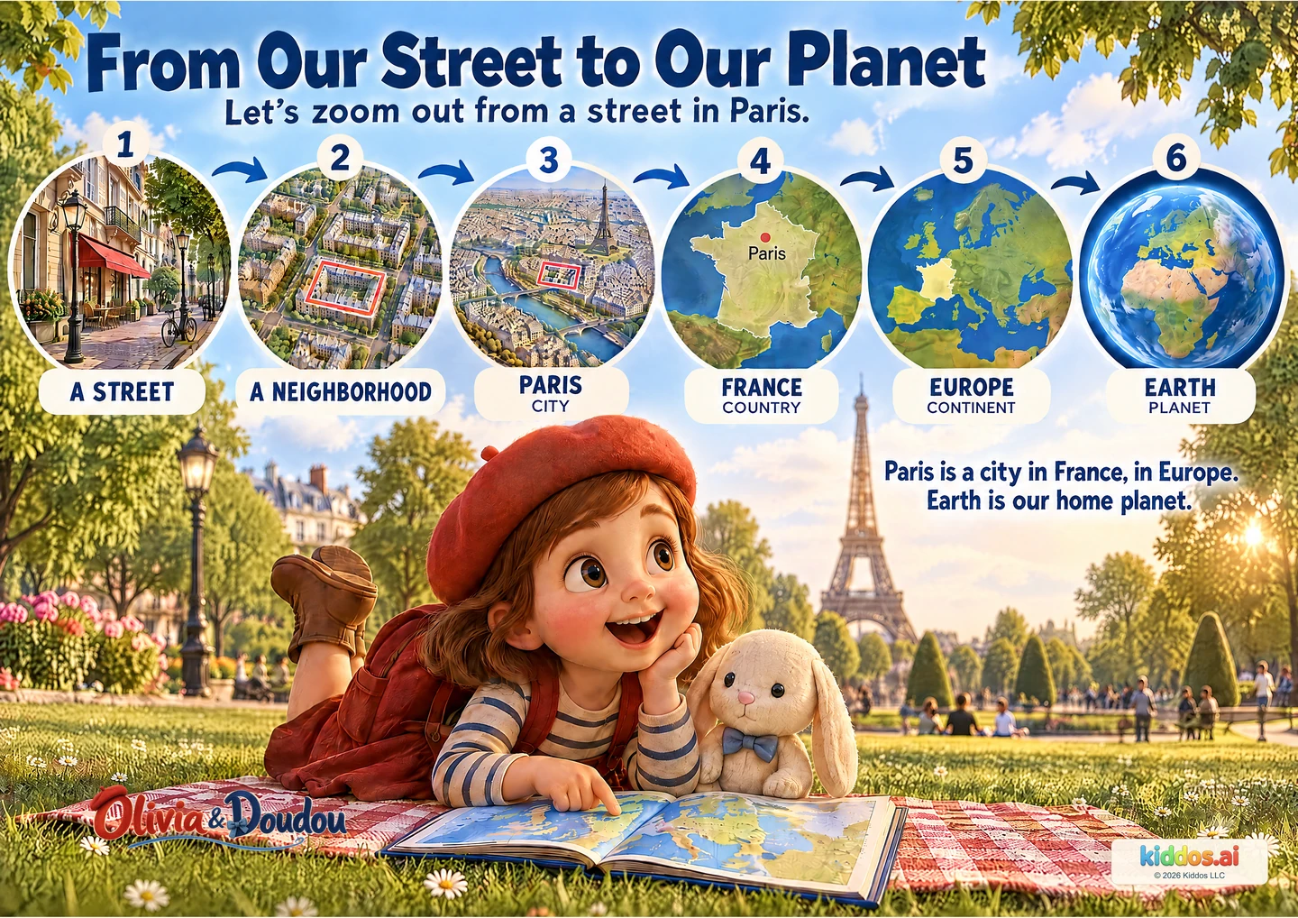
Follow the pictures outward from a public street in Paris. Pause at each label and notice how much more of the world the next view shows.
Which picture shows a larger area: the street or the city?
Start here
Read labels and let children follow the arrows; focus on small place versus larger place.
Explore further
Explain the different map scales and the mainland-France example without equating Europe with the EU.
Three questions to share
1Which picture shows a larger area: the street or the city?
Answer cue: The city view includes a much larger area. The pictures use different scales; they are not objects placed inside physical layers of Earth.
2Which country and continent is Paris in?
Answer cue: Paris is a city in France, in Europe. Pointing to the labels is a useful first answer.
3What is the name of the planet all these places belong to?
Answer cue: Earth. It is our shared home planet.
If your child is unsure: Read labels and let children follow the arrows; focus on small place versus larger place.
Something to try together
Tell a zoom-out story
You’ll need: No materials required; paper is optional.
- Choose a public example, such as the pictured Paris street.
- Say or point: street, neighborhood, city, country, continent, planet.
- Name another city or town you have heard of. It is fine not to know every larger place yet; look together in an atlas later.
What this can show
Can the child distinguish France from Europe and connect Paris to both? No private address or travel experience is needed. Treat the sequence as an example, not a test of where the child lives.
Return to it: Return from Earth to Paris. Which picture would you choose to see one street more closely?
Get the guide and discovery recordFor teachers · About 20 minutes
A small lesson with room to explore.
Learning aim: Use one example to distinguish city, country, continent and planet.
Prepare: Read the picture and answer cues. Have the optional explorer’s notebook available. No materials required; paper is optional.
- 3 min
Notice
Sequence: point along the six views from street to Earth.
- 4 min
Compare
Name: identify Paris as city, France as country and Europe as continent.
- 8 min
Try together
Choose a public example, such as the pictured Paris street. Say or point: street, neighborhood, city, country, continent, planet. Name another city or town you have heard of. It is fine not to know every larger place yet; look together in an atlas later.
- 5 min
Explain
Compare: ask which adjacent view includes a larger area.
Check the idea together
Can the child distinguish France from Europe and connect Paris to both?
What to listen for
The city view includes a much larger area. The pictures use different scales; they are not objects placed inside physical layers of Earth. Paris is a city in France, in Europe. Pointing to the labels is a useful first answer. Earth. It is our shared home planet.
Read the ordered labels aloud and provide an oral sequence for children who find inset maps hard to scan.