Our Wonderful World · Connected learning journey
A world of clues.
A place of your own.
Help Olivia and Doudou fill an explorer’s notebook. Collect clues from ten pictures, then make and explain a pretend place of your own.
Ages 4–8, with a grown-up · Ten posters · Two foundations · One eight-page notebook
Four chapters, one growing idea
Chapter 1
Our place on EarthStart with one place, then discover the larger land-and-water picture.
Chapter 2
Follow land and waterNotice shapes, follow a river and see how land meets the sea.
Chapter 3
Help people find a wayConnect places, turn a view into a map and give a useful direction.
Chapter 4
Tell a journeyChoose how to travel and which landmark will help a visitor recognize the destination.
The two missing foundations
Land, water and one ocean
After stop 2, use notebook page 2. Invent land shapes, mark the water, then return after stop 5 to compare an island with a peninsula.
The adult reads the five ocean names as parts of one connected ocean. No memorization test.
One place, three views
Before stop 7, use notebook page 3. Match the same house and tree from the side, from above and as map symbols.
A precise little diagram makes the change of viewpoint visible before children make a key.
Open the notebook and guide
Choose A4 or US Letter at actual size. Print just the notebook pages you want, single-sided. Adult support and answers are separate. The notebook is primarily white, with outline diagrams; color is optional.
The adult guide includes the sequence, answer support, book connections and factual distinctions. Choose A4 or US Letter and print only the pages you want.
Chapter 1 · Begin with a place
From Our Street to Our Planet
Olivia opens an atlas with Doudou beside her. Your explorer’s notebook begins with one place you notice.
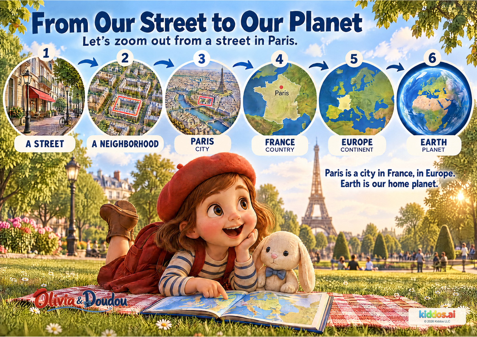
Draw or describe a place from the poster. It can be the public street, the city or Earth.
A conversation with your child
Follow the pictures outward from a public street in Paris. Pause at each label and notice how much more of the world the next view shows.
Which picture shows a larger area: the street or the city?
The city view includes a much larger area. The pictures use different scales; they are not objects placed inside physical layers of Earth.
Which country and continent is Paris in?
Paris is a city in France, in Europe. Pointing to the labels is a useful first answer.
What is the name of the planet all these places belong to?
Earth. It is our shared home planet.
Return another time: Return from Earth to Paris. Which picture would you choose to see one street more closely?
Teacher notes and a small extension
Objective: Use one example to distinguish city, country, continent and planet.
Vocabulary: street, neighborhood, city, country, continent, planet
Look for: Can the child distinguish France from Europe and connect Paris to both?
Younger: Read labels and let children follow the arrows; focus on small place versus larger place.
Older: Explain the different map scales and the mainland-France example without equating Europe with the EU.
Try: Tell a zoom-out story
- Choose a public example, such as the pictured Paris street.
- Say or point: street, neighborhood, city, country, continent, planet.
- Name another city or town you have heard of. It is fine not to know every larger place yet; look together in an atlas later.
No private address or travel experience is needed. Treat the sequence as an example, not a test of where the child lives.
Accuracy and the book connection
This is one example using Paris, not Olivia's established home or every child's location. The France map shows mainland France; France also has overseas areas. Europe is a continent, not the same thing as the European Union. Neighborhood boundaries vary and streets can cross them.
Olivia and Doudou in Paris supplies the familiar destination. The zoom-out sequence adds geographic context rather than asserting a home address or new story event.
Next: Paris belongs to a country and a continent. Next, find Europe on the wider world map.
Chapter 1 · Find the land and water
Our Seven Continents
The atlas shows large regions of land. Water connects this bigger picture.
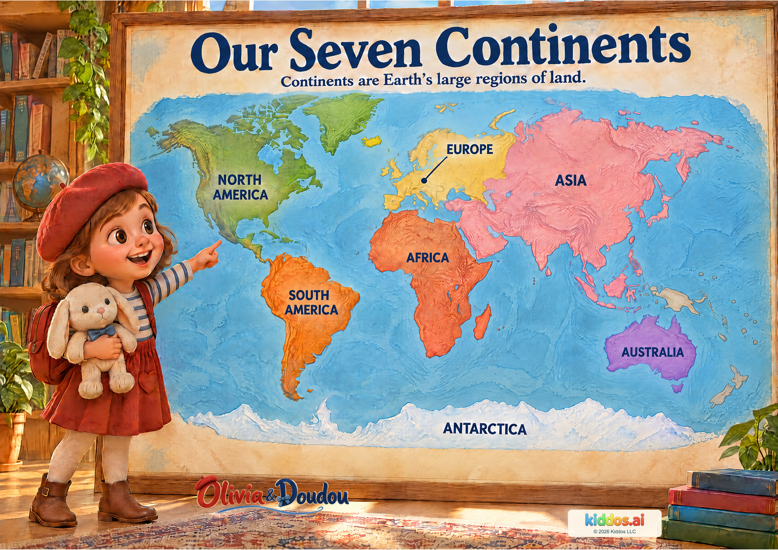
Use notebook page 2 to invent two land shapes with water between them. Keep your drawing separate from the real world map.
A conversation with your child
Find a familiar land shape with Olivia, then read its name. Let your child choose a second continent to locate.
Can you find Africa and South America? What is between them?
Ocean water separates them. It is the Atlantic Ocean; naming it is an optional extension because the poster does not label oceans.
Can you find Europe and Asia? Is there an ocean between them?
Europe and Asia touch. Their different names do not mean an ocean separates them. Help your child follow the boundary between them.
Can you find the continent that stretches along the bottom of this map?
Antarctica. It surrounds the South Pole. Pointing is enough before remembering the name.
Return another time: Find Europe again. Is it separated from Asia by an ocean? Show how you know.
Teacher notes and a small extension
Objective: Name or locate continents and compare their positions on a world map.
Vocabulary: North America, South America, Europe, Africa, Asia, Australia, Antarctica
Look for: Can the child locate two named continents and indicate the water between Africa and South America?
Younger: Offer two names and help find their labels.
Older: Discuss why Europe and Asia can have different names while still touching.
Try: Draw a land-and-water clue
- Draw two large land shapes with water between them.
- Point to the water, then find a similar separation on the poster.
- Explain that your drawing is a simple model; use the poster, not the drawing, to find the named continents.
Stay together and use the picture or an indoor drawing. No trip, purchase, cutting, water access or real address is needed.
Accuracy and the book connection
This uses the seven-continent convention common in US and UK teaching. Other curricula group continents differently or use regional names such as Oceania. Continents are not countries. Europe and Asia share one connected landmass. A flat map changes shapes and apparent sizes; Antarctica is not a straight strip in the real world. The seven labels name the continents. Some nearby islands are shown in a neutral color without a continent assignment. Australia and many neighboring Pacific islands belong to the wider region of Oceania.
Olivia and Doudou in Paris is set in Europe; Olivia and Doudou in San Francisco is set in North America. These real book destinations offer two starting points for a wider map.
Next: A world map shows large shapes. Next, look closer at the shapes the land itself makes.
Chapter 2 · Collect a land clue
Mountains, Valleys, Plains & More
Olivia looks across a landscape. Choose a shape that could belong in your own pretend place.
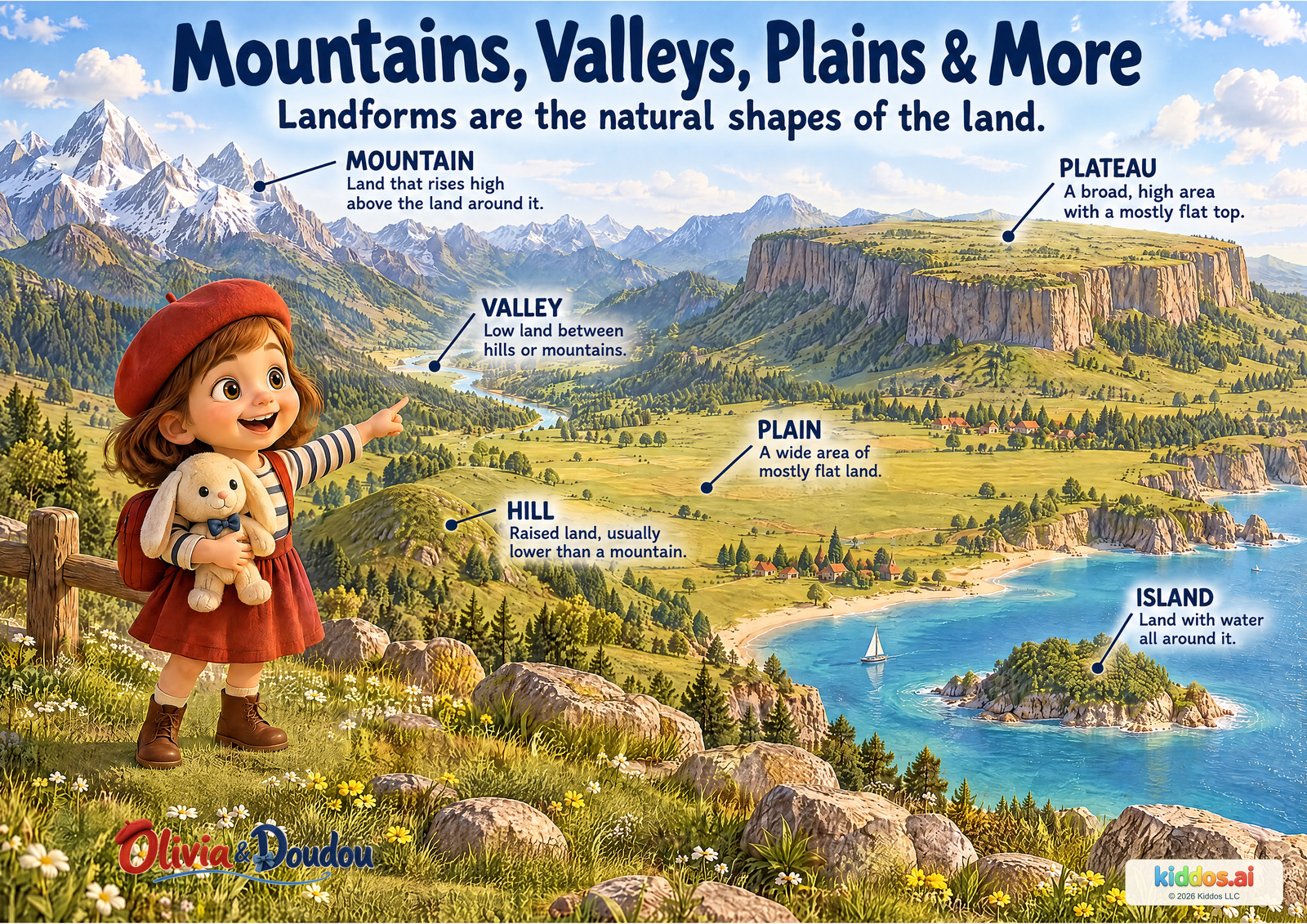
On notebook page 4, sketch or name one landform you want to remember.
A conversation with your child
Look across the landscape with Olivia. Ask your child to choose a shape that catches their eye, then read its label together.
Which two landforms look flat? How are they different?
The plain and plateau both have broad, mostly flat surfaces. The plateau is raised above the land around it. Accept pointing and 'this one is higher.'
Where is the valley? What is on either side?
The valley is the low land between the mountain slopes; the river follows its low floor in this illustration.
What makes this piece of land an island?
Water goes all the way around it. Trace its shore with a finger or gaze.
Return another time: Compare a plain and a plateau: both can be flat, so what else must you notice?
Teacher notes and a small extension
Objective: Identify and compare landforms by their shape and position.
Vocabulary: mountain, hill, valley, plain, plateau, island
Look for: Can the child indicate the plateau's raised flat top and identify water around the island? Accept gestures before technical terms.
Younger: Offer two pictured choices and read the definitions aloud.
Older: Ask why a plain and plateau can both be flat but are different landforms.
Try: Make two land shapes
- Fold or gently scrunch paper into a raised shape, or show one with your hand.
- Keep another part flat. Decide which part could stand for a hill or plain.
- Explain one difference. This is a simple model, not an exact-sized landscape.
Share the looking and vocabulary. No trip, cutting or materials purchase is needed.
Accuracy and the book connection
Real mountains, hills and valleys have many shapes. Snow or a pointed top is not required for a mountain, and there is no single worldwide height boundary between a hill and a mountain. This picture combines examples; it is not a real travel map.
Olivia's travel stories invite close looking at a place. This invented teaching landscape adds geography vocabulary; it is not a scene from a particular book.
Next: Low places and high places shape a landscape. Now follow water downhill through one.
Chapter 2 · Follow the water
A River's Journey
Trace the river from its source toward its mouth. Let its direction guide your drawing.
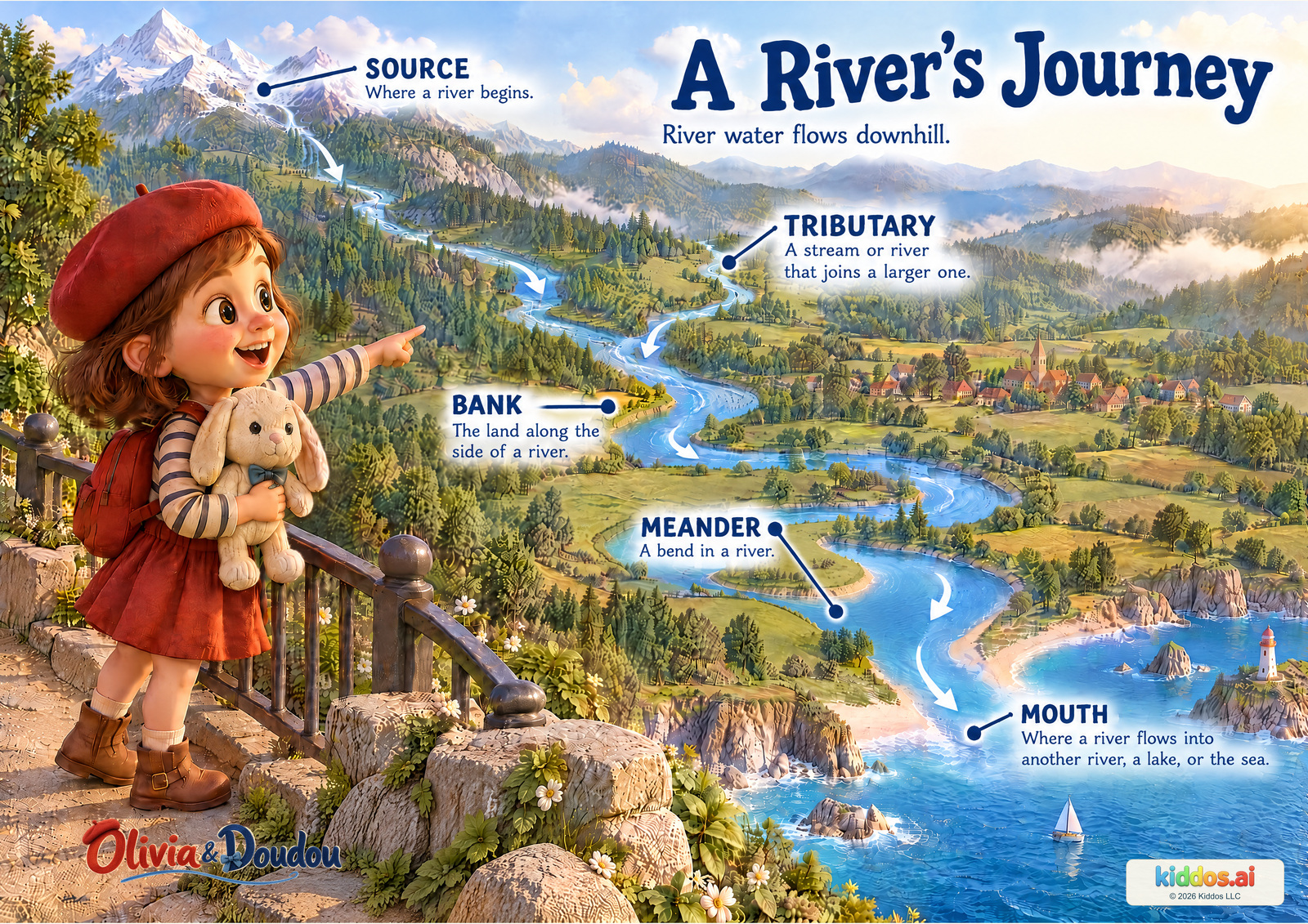
On notebook page 4, draw a river flowing from higher land to the sea, with a smaller stream joining it. Add a downstream arrow.
A conversation with your child
Begin where the river starts. Move a finger or your gaze slowly along the water, letting your child choose where to pause.
Which way does the water go? What helps you tell?
It travels downhill from the source toward the mouth. Follow the downstream arrows and the descending landscape.
What happens where the smaller stream meets the river?
The tributary joins the main river. Their water continues downstream together.
Can you find a bend and the land beside the water?
A bend is a meander. The land along a river's side is its bank, not the water itself.
Return another time: Point to the bank, then the water. Which one is land?
Teacher notes and a small extension
Objective: Trace downstream flow and distinguish source, tributary, bank, meander and mouth.
Vocabulary: source, tributary, bank, meander, mouth, downstream
Look for: Can the child show a joining tributary without tracing away from the main river?
Younger: Use 'begins,' 'joins' and 'bend' before introducing the formal words.
Older: Ask where a river mouth could be besides the sea, and why downhill does not mean south.
Try: Draw a joining river
- Draw one winding river from high land to a lake or sea.
- Add a smaller stream joining its side.
- Add arrows showing the two streams joining and continuing downstream.
Use a drawing indoors; this activity does not require visiting water. If your family later visits water, an adult chooses a safe viewpoint and stays with the child.
Accuracy and the book connection
This example reaches the sea. Other rivers flow into lakes or other rivers. Rivers may be fed by rain, melting snow and groundwater, and flowing downhill does not mean always flowing south.
In Olivia and Doudou in Paris, a boat trip introduces the Seine. This poster is an invented example river, not a map of the Seine or its source.
Next: This river reaches the sea. Next, notice the different shapes along the shore.
Chapter 2 · Read the edge of the land
Where Land Meets the Sea
Olivia studies a model coast. A small land connection can change the name of a shape.
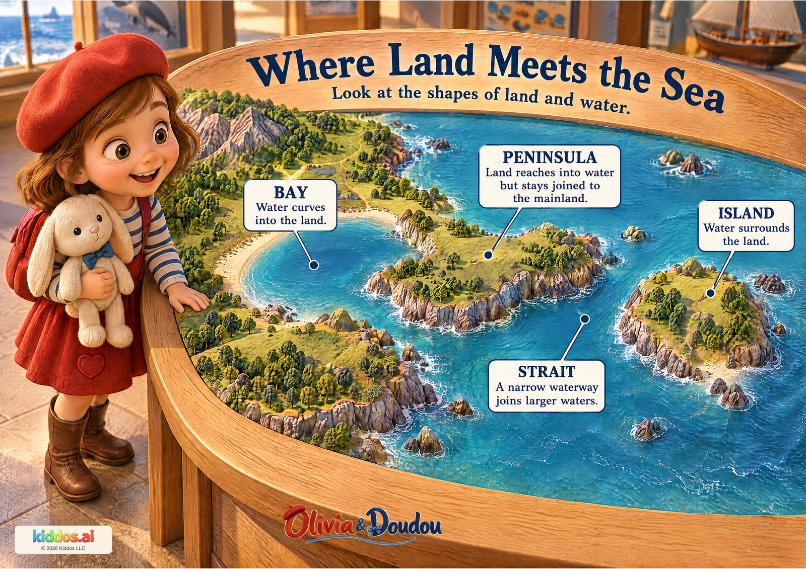
Return to notebook page 2. Trace water around an island. Add a peninsula that stays joined to a larger land shape.
A conversation with your child
Trace one coastline slowly. Notice when water surrounds land and when land remains connected.
Which land has water all the way around it?
The island. Follow its complete shore without finding a land connection.
How is the peninsula different from the island?
It is still joined to the mainland, while water reaches around most of it.
Which label names narrow water, rather than land?
Strait. The narrow passage connects the larger water areas on its two sides. The bay is water curving into the land.
Return another time: Cover the labels. Can you still explain which shape is an island and which is a peninsula?
Teacher notes and a small extension
Objective: Distinguish an island and peninsula, and identify a bay and a strait from land-water relationships.
Vocabulary: bay, peninsula, island, strait
Look for: Can the child follow the island shore and identify the peninsula’s land connection?
Younger: Begin with island versus connected land; add bay and strait later.
Older: Explain how a strait connects larger waters while a peninsula connects to land.
Try: Draw two different shores
- Draw an island with a complete ring of water around it.
- Draw a second land shape still joined to a larger area of land.
- Explain why the second one can be a peninsula and the first cannot.
Stay together and use the picture or an indoor drawing. No trip, purchase, cutting, water access or real address is needed.
Accuracy and the book connection
The museum relief is a model, not a real coast or walking route. A bay can open into a sea or a lake. A strait is water; a peninsula is land. Do not infer depth, safe swimming or scale from the model.
Olivia and Doudou in San Francisco introduces a coastal city and the Golden Gate Bridge. This separate model helps name land-water shapes without claiming to map San Francisco Bay.
Next: Land and water can separate places. Next, find something people build to connect them.
Chapter 3 · Connect two places
Nature & People Shape Places
From the train window, Olivia notices a bridge crossing a river. Think about the people who use it.
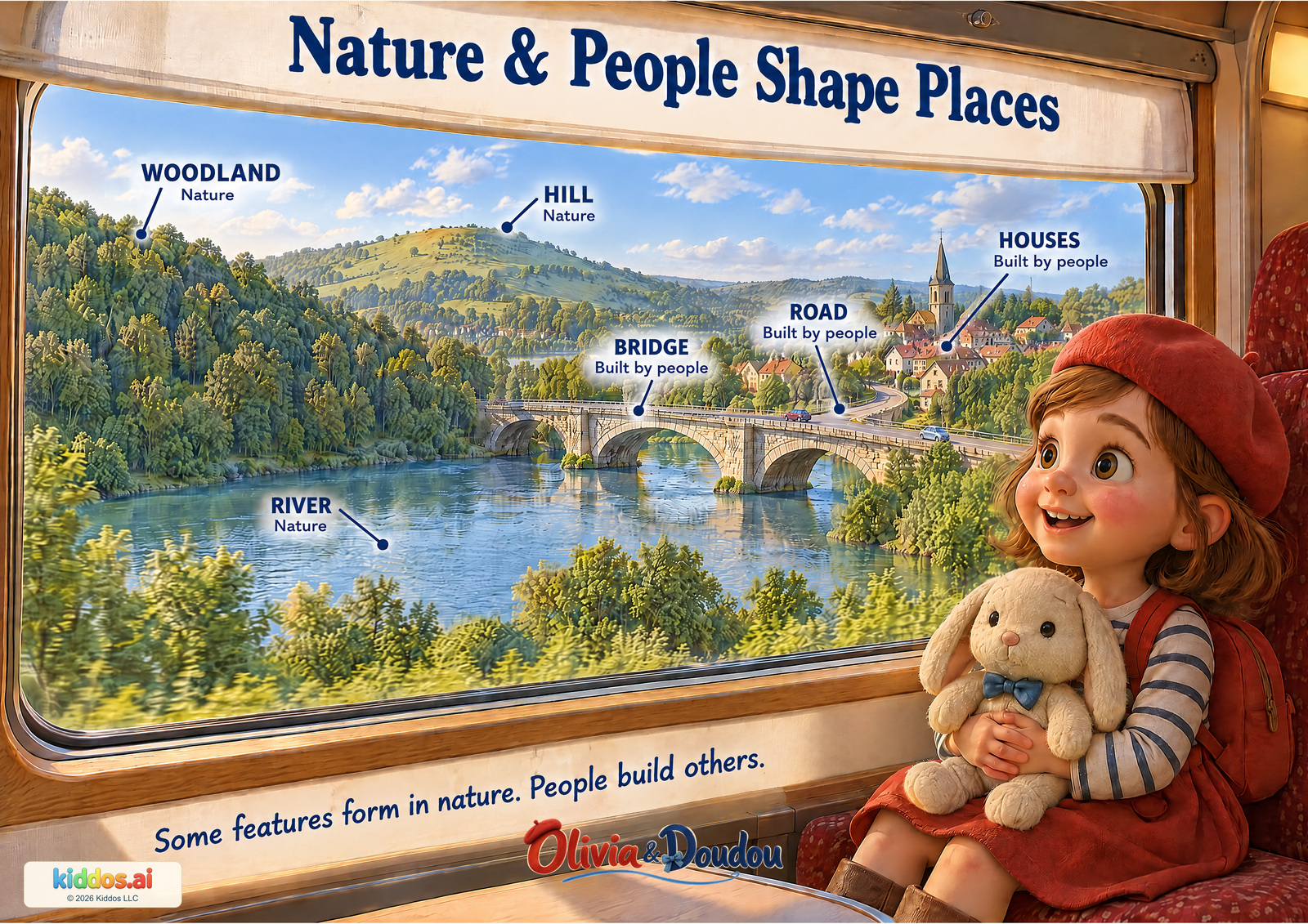
On notebook page 5, help someone travel from START to the library on the other side. Draw a bridge or a ferry route.
A conversation with your child
Look out of the train window with Olivia. Choose one feature people built and one that forms in nature.
Which labeled feature carries the road across the river?
The bridge. People built it to span the water.
Which three labeled features belong to the nature group?
River, hill and woodland in this scene.
How do a natural feature and a built feature meet here?
The bridge crosses the river; the road connects to it. Accept another accurate relation supported by the picture.
Return another time: If the bridge were missing, what would someone need to cross the water?
Teacher notes and a small extension
Objective: Compare natural and human-built landscape features and describe how one built feature relates to nature.
Vocabulary: river, hill, woodland, bridge, road, houses
Look for: Can the child identify one natural and one built feature and describe their relationship?
Younger: Offer river versus bridge as the first pair.
Older: Discuss how people can change a natural feature without making it cease to matter.
Try: Add a bridge to a drawing
- Draw a river and a few houses on opposite sides.
- Add a bridge and a connecting road.
- Point out what represents nature and what people would build, and explain why the bridge helps.
Stay together and use the picture or an indoor drawing. No trip, purchase, cutting, water access or real address is needed.
Accuracy and the book connection
Natural and built features often interact. People can plant woodland, change river channels or reshape hills. This scene introduces a useful first comparison, not a claim that every tree or river is untouched by people. Both kinds of features deserve care.
Olivia and Doudou in Paris and Olivia and Doudou in San Francisco invite children to notice rivers, bridges and buildings. This train-window valley is a new learning view, not a new canonical journey.
Next: A crossing helps people move. Next, show a place clearly so another person can find that crossing.
Chapter 3 · Make a picture someone can use
How to Read a Map
Olivia’s practice map uses small pictures for real features. Your symbols can do that too.
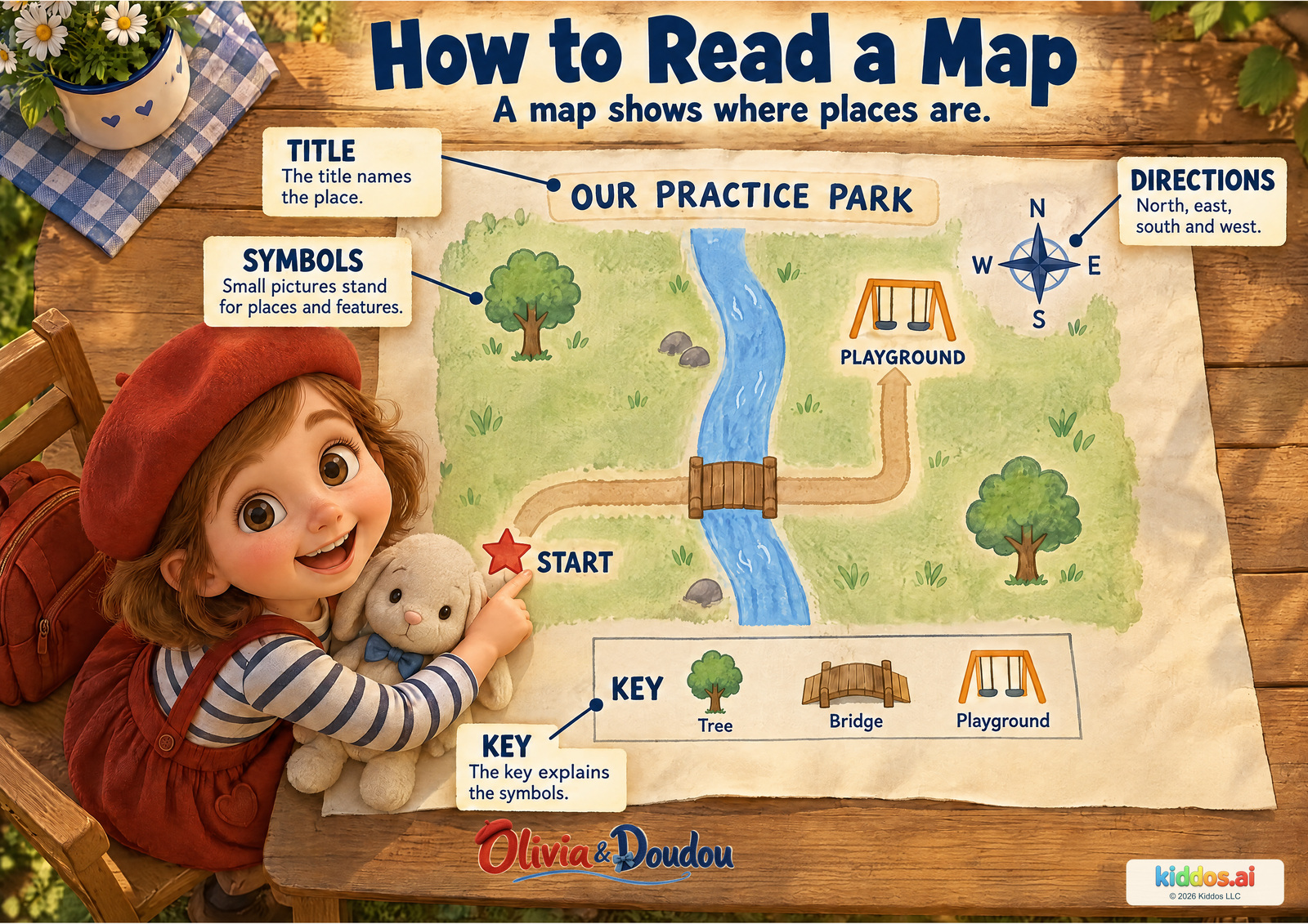
Try the three views on notebook page 3. Then choose symbols and meanings for your own key on page 6.
A conversation with your child
Pretend you and Olivia are reading this practice map together. Begin with its title, then choose one symbol in the key and find its match.
What does the title tell us?
The map shows an imaginary practice park. It is for learning, not a real walking route.
How does the key help you?
It explains what the tree, bridge and playground symbols mean. Find the same shapes on the map.
How can you go from the star to the playground without crossing through the water?
Follow the path from START across the bridge, then continue along the path to the playground. Use the actual map path; it is not a real-world navigation instruction.
Return another time: Ask a partner to find a symbol using only your key. What could make the match clearer?
Teacher notes and a small extension
Objective: Use a title, key and compass rose to interpret a simple map and follow a connected path.
Vocabulary: map, title, symbol, key, north, east, south, west
Look for: Can the child use a key symbol correctly and keep the route on the pictured path?
Younger: Offer one symbol at a time and trace together.
Older: Ask the child to describe the path with east/north as shown by this map's compass rose.
Try: Make an imaginary park map
- Draw a made-up park with a path and two features.
- Choose a small symbol for each feature and repeat it in a key.
- Invite someone to match the symbols and trace your path.
Keep the map imaginary or of a public example. Do not ask the child to record or share a home address, school location or personal route.
Accuracy and the book connection
North points toward the top of this map because its compass rose says so. Not every map is drawn with north at the top. Symbols and keys can differ between maps.
Olivia's books explore real places with Doudou. This imaginary park is a practice diagram, not an additional book destination.
Next: The key tells us what a symbol means. Next, use directions to say where it is.
Chapter 3 · Give a useful direction
North, South, East & West
Begin at the compass center. Direction words need a clear starting point.
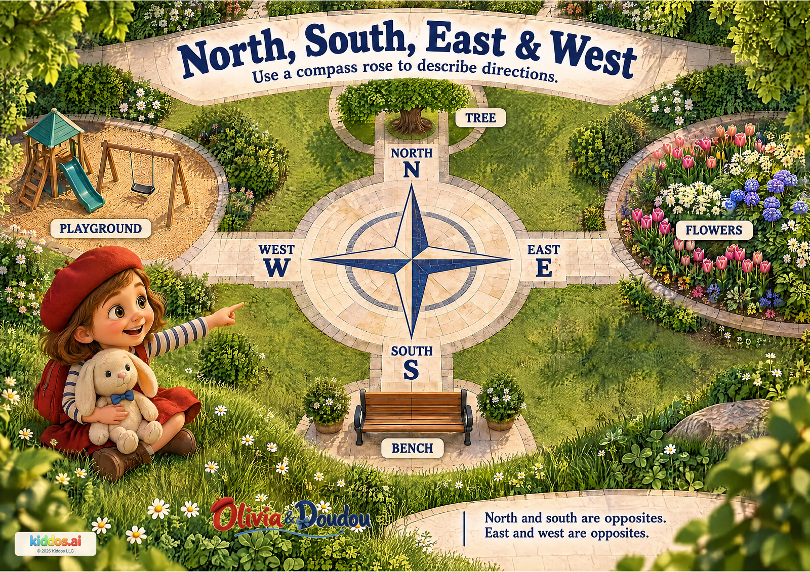
Use page 6: point north from the center, then show the opposite direction. Add a matching north arrow to your map on page 7.
A conversation with your child
Begin at the center of the compass rose. Follow one tip with your eyes before naming its direction.
What is east of the compass?
The flowers are east, to the right of the compass on this picture.
Which direction takes you from the compass toward the tree?
North. Follow the north tip upward to the tree.
Which two directions are opposites?
North and south are opposites; east and west are opposites. Show a pair across the compass center.
Return another time: Turn the paper. The N still marks north on the drawing; is it still at the top of your view?
Teacher notes and a small extension
Objective: Use four compass directions to describe the positions of places from one clear reference point.
Vocabulary: north, east, south, west
Look for: Can the child identify the flowers as east from the compass center and show one opposite pair?
Younger: Read one direction at a time; match it to a pictured object.
Older: Rotate the drawing and explain why the letter N still marks north in the drawing.
Try: Make a four-direction picture
- Draw a cross and put N at the top, E at the right, S at the bottom and W at the left.
- Choose a center and draw one simple place at each end.
- Give a direction from the center and ask a partner to point to the matching place.
Stay together and use the picture or an indoor drawing. No trip, purchase, cutting, water access or real address is needed.
Accuracy and the book connection
The picture is a practice garden, not a real navigation route. North is at the top here because the compass rose shows it. Turning yourself does not change north; left and right depend on which way you face. Map pages can also be rotated.
Olivia’s Paris and San Francisco stories celebrate noticing places. This invented garden extends that habit into direction language; it is not a location from a book.
Next: A map can show a route. Next, decide which kind of travel fits the land and water along it.
Chapter 4 · Choose a way to travel
Ways We Travel
Olivia watches a harbor. The route helps you choose a suitable way to travel.
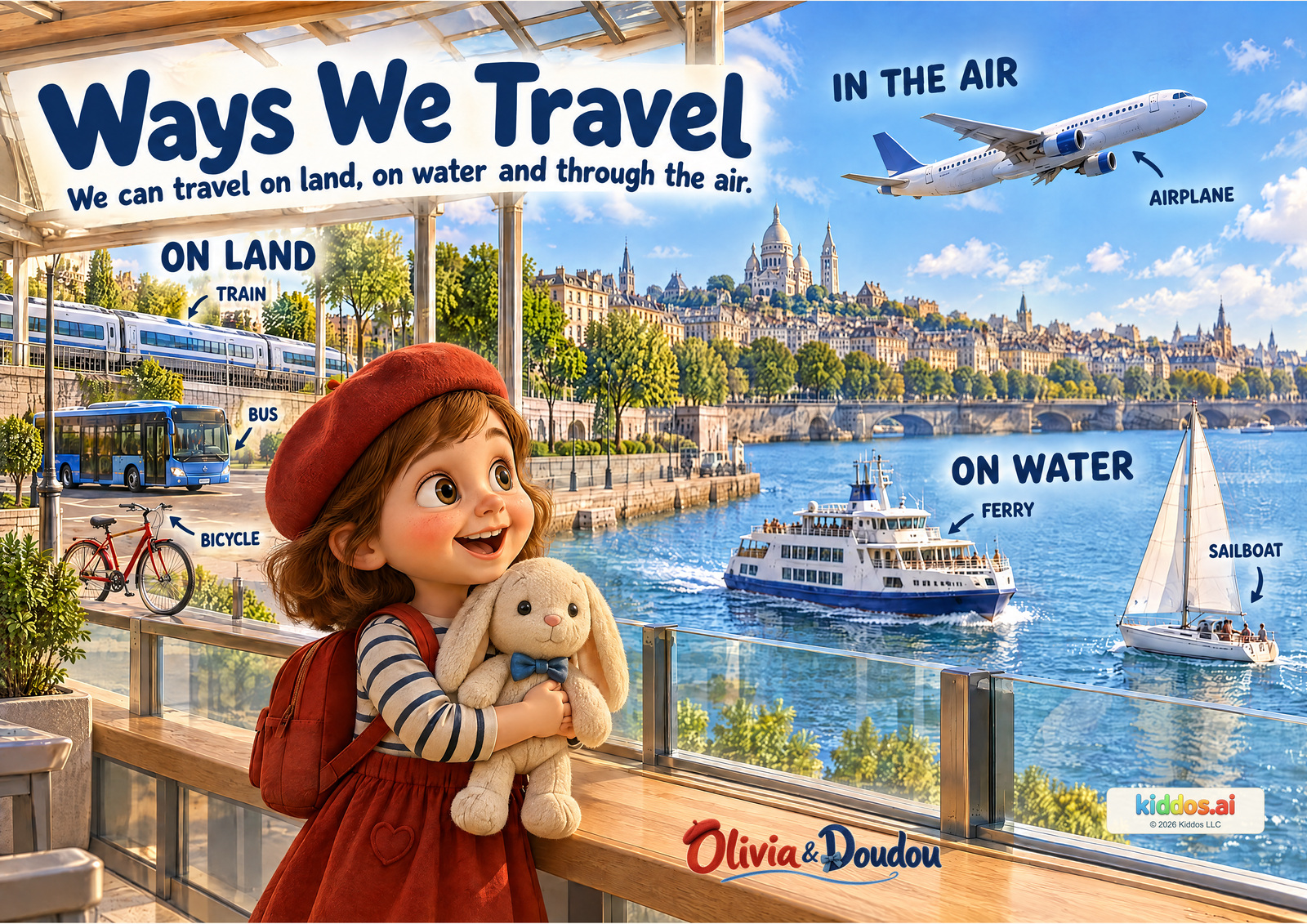
On page 7, make your pretend map using your key and crossing idea. On page 8, choose how a visitor will travel.
A conversation with your child
Choose one pictured vehicle and ask where it travels. Let the scene supply the answer.
Which vehicles travel on water?
The ferry and sailboat.
Which three vehicles travel on land?
The train, bus and bicycle. Trains use rails; buses and bicycles use suitable land routes.
What could carry people across this harbor without a bridge?
The ferry. A sailboat can also travel across water. Invite an explanation using the pictured water route.
Return another time: If your route crosses water without a bridge, which part needs a different way to travel?
Teacher notes and a small extension
Objective: Sort six familiar vehicles by the environment in which they travel and explain a choice.
Vocabulary: on land, on water, in the air
Look for: Can the child sort a land vehicle and a water vehicle and explain a reasonable water crossing?
Younger: Choose between two pictured vehicles.
Older: Describe a journey using two different transport environments.
Try: Plan an imaginary two-part journey
- Draw a simple home-to-harbor route and water to an island; do not use a real address.
- Choose a land vehicle for the first part and a water vehicle for the crossing.
- Explain why a land vehicle alone cannot complete this water crossing when there is no bridge.
Stay together and use the picture or an indoor drawing. No trip, purchase, cutting, water access or real address is needed.
Accuracy and the book connection
These groups describe ordinary travel. An airplane also rolls on the ground for takeoff and landing, and some special vehicles work in more than one environment. People also walk or use mobility aids; the six pictured vehicles are not every way to travel.
Olivia and Doudou in San Francisco includes cable-car travel, while Olivia and Doudou in Paris includes a boat ride. The six-vehicle harbor is a new teaching scene, not a retelling of either trip.
Next: You have a route and a way to travel. Next, choose a feature that will help the visitor recognize the destination.
Chapter 4 · Make the destination memorable
Discover World Landmarks
Olivia’s album brings together three separate cities. A distinctive feature can help someone recognize a place.
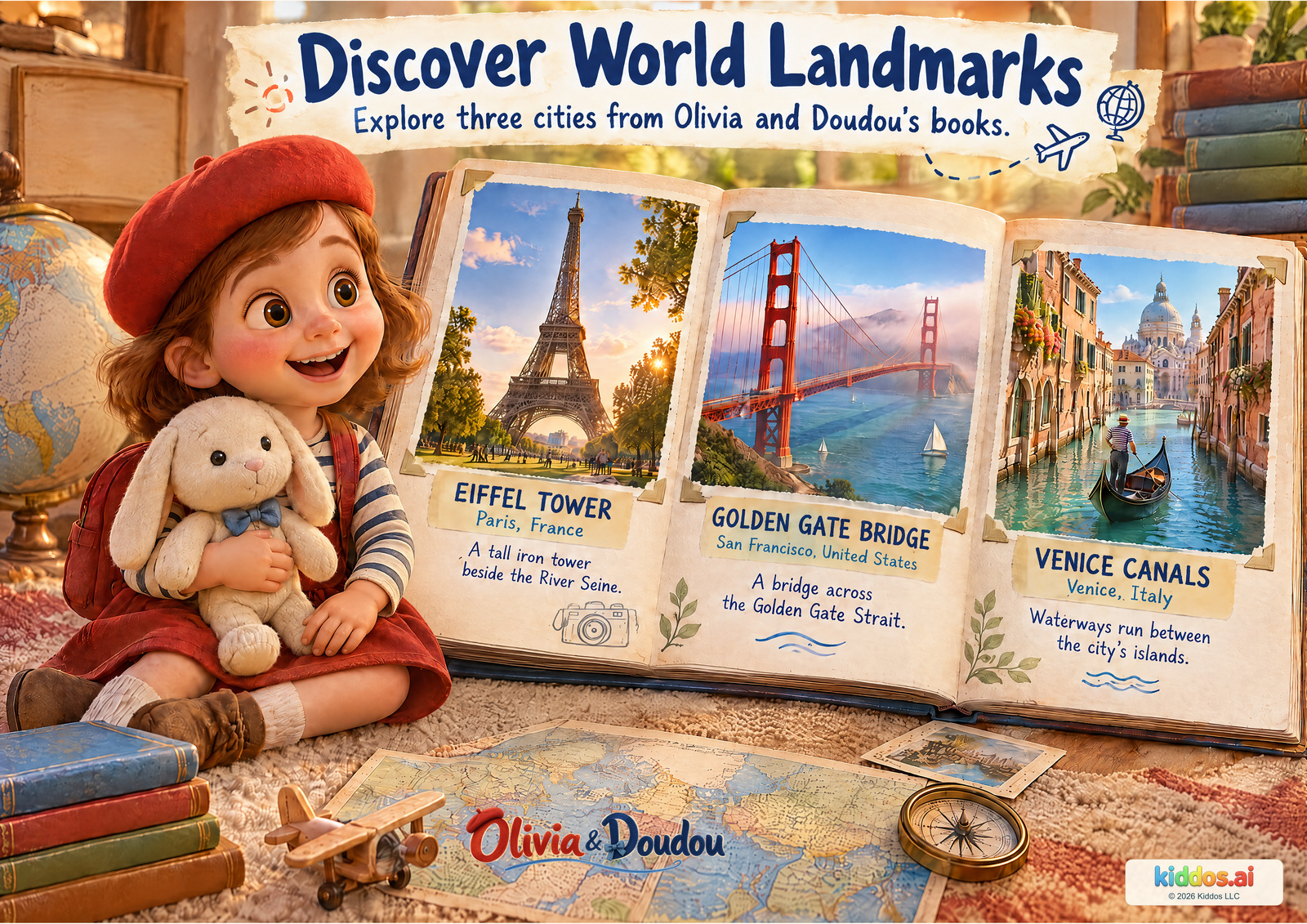
Add a pretend landmark to page 7. Use page 8 to tell your route, your way across the water and what the visitor will see on arrival.
A conversation with your child
Open this illustrated travel album with Olivia. These are three separate places from her book destinations, and you can explore them from home.
Can you find a tower, a bridge and a waterway?
The Eiffel Tower is in Paris, the Golden Gate Bridge is at San Francisco, and the canals are in Venice.
What does the bridge cross? What could move along the canals?
The Golden Gate Bridge crosses a sea strait. Boats can travel along Venice's canals.
What is alike or different about these places?
Accept pictured evidence: tall tower versus long bridge, iron structure versus buildings beside water, or different ways of moving around. There is no single required comparison.
Return another time: Invite a partner to follow your map. Can they recognize your landmark from your description?
Teacher notes and a small extension
Objective: Identify three destination features and compare their shapes and uses.
Vocabulary: landmark, tower, bridge, canal, strait
Look for: Can the child pair one feature with its city and support a comparison with visible evidence?
Younger: Offer a tower-versus-bridge choice and read place names aloud.
Older: Discuss bridge function and distinguish a strait from a river or canal.
Try: Design a pretend landmark
- Choose a purpose: a tower for looking out, a bridge for crossing, or a waterway for boats.
- Draw or describe your invented place.
- Explain how someone could use it. Call it pretend, and keep it separate from the real landmark names.
This is a drawing or storytelling activity, not an instruction to build or climb a structure.
Accuracy and the book connection
The three views are separate cities, not neighboring parts of one landscape or a complete picture of world cultures. These examples are from France, the United States and Italy. Families do not need to travel to learn about them.
Continue with the existing books Olivia and Doudou in Paris, Olivia and Doudou in San Francisco, and Olivia and Doudou in Venise. The last book's title uses 'Venise'; English geography labels use 'Venice'. The canal picture is an editorial example of that destination, not a claim about a specific unnamed bridge in the story.
Next: Return to the first page. Show one detail you can explain now, and choose something else to wonder about.
What a useful finish looks like
Let a partner follow the child’s pretend map. Listen for an explanation and invite one small revision if a clue is confusing.
- The child points to picture evidence for one comparison.
- Their map uses an explained symbol consistently.
- Their route crosses water in a plausible way.
- They can tell a partner how to recognize the destination.
At home
Choose one poster and one question for 5–10 minutes. Stop after one useful observation; return when the child wants to.
For ages 4–5, offer two choices, use two map symbols and co-draw. A pointed explanation is enough.
In a classroom
Use ten 10–15 minute sessions, with extra time for the two foundation pages and the final map. Model first, try together, then let children explain in pairs.
For ages 6–8, ask for a reason, a consistent key and a route another person can follow. Let the child revise a confusing clue.
Read prompts aloud. Accept speech, signing, pointing, eye gaze, drawing or adult scribing. Describe position and shape as well as color. Enlarge a page when helpful; hand control and spelling are not assessed.
Use invented places or the public examples shown. Do not put a child’s home address, school or daily route on a map intended for sharing.
Source notes
An editorial learning frame using existing reviewed posters, not a new canonical trip or book. Doudou remains an inanimate plush companion.
A later, separately reviewed chapter could broaden everyday life and places beyond the present France, US and Italy book examples. This package does not claim comprehensive world-culture coverage.
- Landforms — Mountain, hill, valley, plain and plateau definitions.
- Islands — Island surrounded by water.
- Rivers — River flow and sources.
- River Terms — Tributary: a stream flowing into a larger stream or body of water.
- Meander — River bends.
- Maps — Four cardinal directions and compass rose use.
- Earth — Earth is our home planet.
- Continents — Continental land regions; Asia largest, Australia smallest.
- Eiffel — Eiffel Tower in Paris, France by the Seine.
- Golden Gate — Golden Gate Bridge crosses the Golden Gate Strait.
- Venice — Venice, Italy: canals and islands.
- River Mouth — A river mouth enters a lake, larger river or ocean; vocabulary describes a bank as adjoining land.
- Continent Policy — Seven-continent convention and Europe-Asia boundary.
- Primary Geography — Elementary geography vocabulary, directions, natural and human features.
- Bay — Bay is water partially enclosed by land.
- Peninsula — Peninsula stays connected to mainland while surrounded by water on most sides.
- Strait — Narrow waterway connects larger waters.
- Place — Physical and human features of places interact.
- Transport — The DOT homepage groups transportation under Air, Ground, Rail and Water. Our six vehicle examples describe ordinary observable operation; no specific six-vehicle classification is attributed to DOT.
- Global Ocean — One connected global ocean; five named ocean regions in the convention used here.
- Map Perspectives — Maps as overhead representations; matching features and symbols; map legends. Original park diagrams created for this companion, not adapted from the USGS story.
NOAA ocean and USGS viewpoint pages checked October 10, 2026. Remaining links retain the reviewed poster evidence. Parent/teacher scripts are editorial suggestions, not evidence of measured learning outcomes.